Show table of content Hide table of content
The unexplored depths of our oceans have long fascinated scientists and adventurers alike. Recent breakthroughs in satellite technology have revolutionized our understanding of what lies beneath the waves. The NASA-CNES collaboration on the Surface Water and Ocean Topography (SWOT) satellite has unveiled an unprecedented detailed mapping of the ocean floor, revealing nearly 100,000 seamounts and numerous other submarine features previously hidden from human knowledge.
Revolutionary mapping reveals hidden underwater mountains
The ocean floor remains one of Earth’s least explored frontiers, with only about 25% mapped through direct sonar measurements. This knowledge gap has significantly hampered our understanding of underwater ecosystems and geological processes. The SWOT satellite represents a major leap forward in oceanographic research capabilities, offering unprecedented precision in seafloor mapping.
David Sandwell, a geophysicist at Scripps Institution of Oceanography, along with his research team, has utilized a full year of SWOT satellite data to create one of the most comprehensive maps of undersea terrain ever produced. Their findings, published in Science in December 2024, have more than doubled the number of known seamounts from 44,000 to approximately 100,000.
These underwater mountains rise at least 500 meters from the seafloor, creating unique ecological environments. “The SWOT satellite has been a breakthrough in our ability to map the ocean floor,” noted Sandwell, who has been using satellite data for seafloor mapping since the 1990s. The newly discovered formations include seamounts, abyssal hills, and submarine continental margins where continental crust meets oceanic crust.
Seamounts often serve as biodiversity hotspots, concentrating nutrients on their slopes and attracting marine organisms. In some extraordinary cases, deep-sea explorers have encountered unusual creatures at depths exceeding 9,000 feet, demonstrating how these underwater features create oases in otherwise barren regions of the ocean floor.
How satellite technology detects underwater features
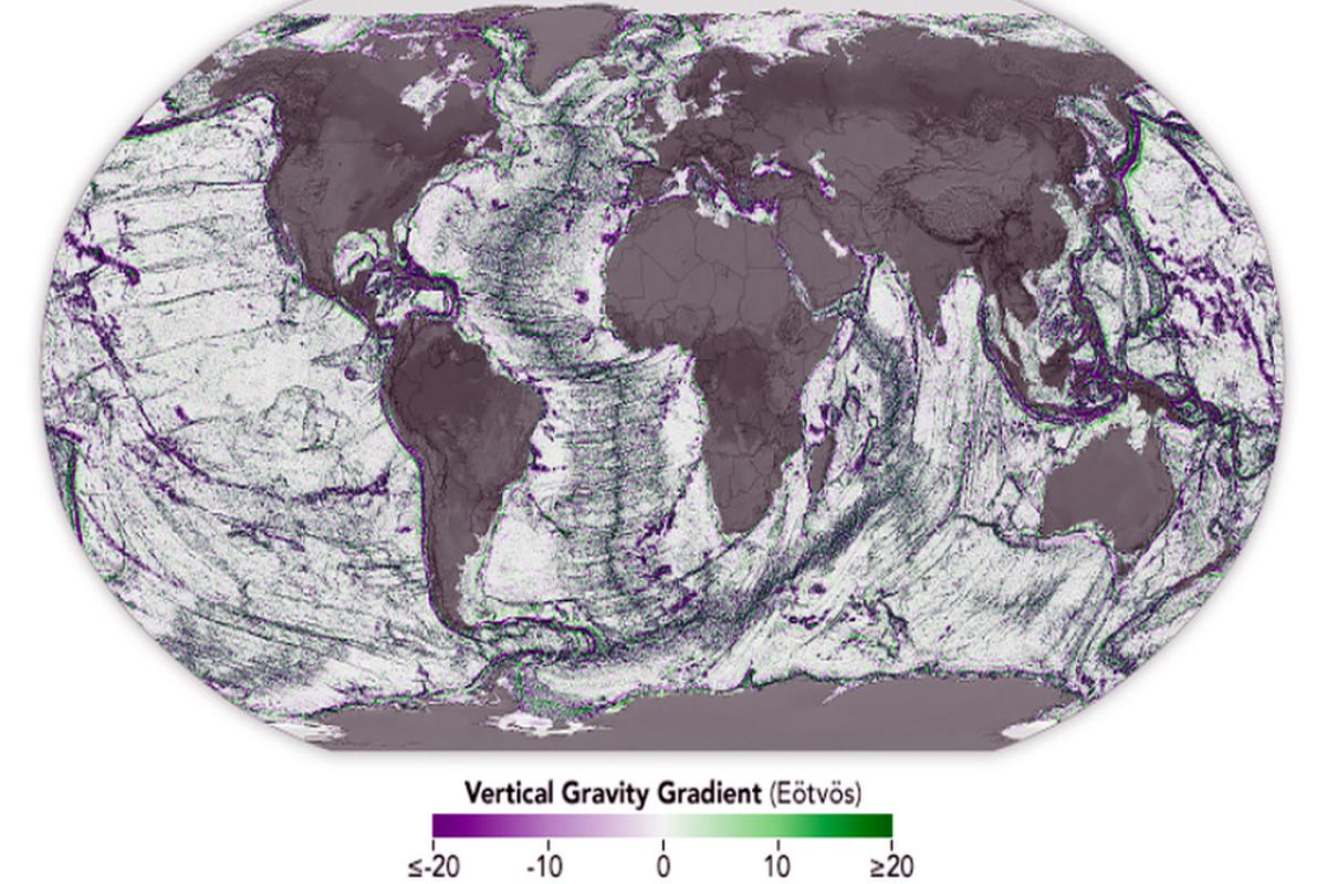
The innovative approach behind SWOT’s underwater mapping capabilities relies on detecting gravitational variations. Geological formations like seamounts have greater mass than their surroundings, exerting slightly stronger gravitational forces that create measurable bulges on the sea surface. These subtle gravitational signals help researchers predict the type of seafloor formation producing them.
SWOT covers approximately 90% of the planet every 21 days, making repeated observations that can detect centimeter-scale differences in sea surface height caused by underlying features. The satellite’s enhanced vision captures details previously invisible to space-based instruments, including seamounts less than half a kilometer tall.
Science This strange red lake in Tanzania turns animals to ‘stone’.
The technology distinguishes between areas of reduced gravity (appearing violet on maps), which correspond to depressions in the ocean floor, and areas of increased gravity (appearing green), indicating more massive elevated structures. This color-coding system creates a visual representation of submarine topography with unprecedented clarity.
The extreme conditions of the deep sea present unique challenges for direct exploration. Some researchers have pushed human limits in underwater environments, with one scientist breaking the world record for longest time underwater, demonstrating the difficult conditions that make satellite mapping such a valuable alternative for studying vast ocean regions.
Abyssal hills and their geological significance
Perhaps the most surprising aspect of SWOT’s findings involves abyssal hills, which cover approximately 70% of the ocean floor. “Abyssal hills are the most abundant landform on Earth,” explained Yao Yu, oceanographer at Scripps Institution of Oceanography and lead author of the research paper. “These hills are only a few kilometers wide, making them difficult to observe from space. We were surprised that SWOT could see them so well.”
These underwater formations occur in parallel bands, resembling washboard ridges, where tectonic plates move away from each other. Their orientation and extent provide critical insights into historical tectonic plate movements, helping scientists reconstruct Earth’s geological evolution. The precise mapping of these features enhances our understanding of deep-sea currents and tidal interactions.
Explorations of extreme environments, though usually focusing on places like highly radioactive locations on land, share methodological similarities with deep-sea research, requiring specialized equipment and careful planning to document previously unseen phenomena.
Practical applications of detailed ocean floor maps
Beyond scientific discovery, precise seafloor maps serve essential practical purposes across multiple industries. Navigation safety improves dramatically with better understanding of underwater topography, helping ships avoid hazards. Submarine communication cable installation, crucial for global internet infrastructure, depends on detailed knowledge of the ocean bottom for optimal routing and placement.
The maps also enhance our understanding of deep ocean currents and tides, which influence marine life distribution and global climate patterns. By documenting how seamounts and other formations affect the movement of heat and nutrients in deep waters, scientists can better predict changes in marine ecosystems and climate systems.
While mapping uncovers fascinating geological features, it also reveals potential hazards. Just as researchers occasionally document dangerous organisms in shallow waters, like potentially harmful turtles found in English lakes, deep-sea exploration identifies underwater features that could pose risks to submarine infrastructure or trigger geological events.
Science 50 years later, a quantum mystery has finally been solved.
The NASA-CNES SWOT satellite represents a watershed moment in ocean exploration, transforming our understanding of Earth’s last frontier. As researchers continue analyzing this wealth of data, our knowledge of submarine landscapes and their influence on ocean processes will undoubtedly expand, revealing more secrets from the mysterious world beneath the waves.


